I did a drive down from Seattle to LA from May 30 – June 1. It was pretty pleasant, but really rather a lot of time in the car. However, I had a good travelling companion, and the scenery was mostly good, so , yay.

Definitely pretty, when you can see it. At the time, I was too busy shoving off mosquitoes!
But then, and more to the point, I did a two-night backpack in southwestern Yosemite National Park, dropping south from Bridalveil Campground and doing 30 miles in 3 hiking days (1 afternoon, 1 full day, 1 morning), with about 2300′ of total elevation change, though a bit more up and down on the route itself. My issue of Sierra North (8th ed?) refers to this as the Buena Vista Crest, and I think the current ed refers to it as Royal Arch Lake (ed. – Sierra North has the similar area as Royal Arch, Falcon Guide Hiking Yosemite lists the route we did as Buena Vista Crest). Dave, Gretchen, Erin, and Amittai came along for this sucker. We spent the night before at Summerdale Campground, just south of the park, which I only managed to snag because of a weirdness with it only being listed via direct search on the reservations page. I win, I guess!
We then went north, picked up our permit at Wawona, and then drove up to Glacier Point Road and Bridalveil Campground, where we parked, and began our trip.

Shasta is…really large. (From the Seattle drive, not Yosemite, of course)

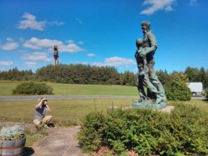
Group of us when we finally got to the *real* trailhead
Anyway. Yosemite. We arrived the night before (after a whole debacle with planning to take my car, and the window that only goes down being opened, so ending up having to take Amittai’s car, and…yeah. We got there.), and camped at Summerdale Campground. It was fine, and very close to the Wawona entrance to the park. We stopped at the ranger station near Wawona in order to pick up our wilderness permit, and Amittai got himself a Jr Ranger tshirt. Mega-awesome. From there we drove up the Glacier Point Road to just outside Bridalveil Campground (still closed for work during the early season) and parked off the main road. We ended up having to walk almost a mile on concrete road, which is a bit sad, since we could have parked a 1/4 mile further and walked about the same length, but entirely on trail. Ah well.
<

Woodsy *and* meadowy. Ayup.
Day 1: Anyway, they were repaving the roads in the campground as we walked through it on the way to the trailhead. The road working crew were the last people we saw for the next day and a half though, which was pretty awesome. We headed out on the trail around 10.30 AM, and began walking in the woods along a creek. We passed the turnoff for Ostrander Lake, and at some point after a steep climbing bit of trail, we reached a nice open area, so headed over there and took a bit of a break. We also tried to get some views, but since there were a bunch of fires around Yosemite Park, everything was a bit smoky, and the views weren’t all that great. Anyway, we just kept going along, passing forest and meadow in pretty quick succession. There were a *lot* of mosquitoes. We at one point were taking a trail through a meadow that had turned into a defacto creek, since I hear that water heads to the lowest point!

Maybe hard to see, but the whole trail is water.
Eventually we reached the trail junction for the loop part of the trail, and turned left. We had initially been debating just where to stop, but by the time we reached Chilnualna Lake, we had just gone up an exceedingly unpleasant slope. As the lake was 11 mi from the trailhead (though only 1000′ feet up) we were pretty ready to crash. Also, the mosquitoes were disturbingly active, so we took it as our clue to set up camp for the night.

We look like we’re camped in some sort of ad. Mmm.

This is what happens when you try to get a photo, but the skeeters won’t leave you alone!
Day 2: The next morning we got up and went around the loop. The first notable thing we got to was Buena Vista Lake. Shortly after that, Amittai and Gretchen (somewhat to my unenthusiasm, but it all worked out) took off and took a “shortcut” that took them up and along this ridge that amittai wanted to traverse. Dave and Erin and I continued along the trail. We went up a bit, then went through this glorious dry meadow and made our way over to Royal Arch Lake.

Royal Arch Lake was probably the single most scenic thing on this backpack.
This was the most notable attractive feature on the trip. It has a beautiful rock arch overlooking the lake, and the colors were amazing. We took a bit of a lunch break here, enjoying the view, but not so much the mosquitoes (as always). We continued on and quickly got to the trail junction where we were to meet up with gretchen and amittai. They weren’t there yet, and I still hadn’t learned my lesson to bring the walkies with me, so we sat down and waited, and played cards for about an hour until they showed up. We continued along the trail, which, according to the map, was supposed to go along a couple more little lakes, but it turns out they were just over a tiny ridge from the trail, so weren’t really visible from where we were.
We were pretty tired by the time we got back to the loop junction (at which point we were now retracing our steps) and we went a little farther before we needed to take a break. We were at a location where we *could* have maybe camped, but Gretchen and I went along until we found a much better place (going forward without packs) and we went back to fetch everyone else. Unless possibly we were just looking for water and we found this anyway 🙂 Regardless, it was a nice big open clearing in a wooded area, next to, but not in, a meadow, and right off the trail. We set up camp for the night, and were actually able to have a campfire since there was a fire ring there. Dinner was good, and we all collapsed into exhausted sleep.

Through a field, on the final day
Day 3: That morning as we were packing up, we saw our first other people of the trip. A few other guys were coming in. Anyway, we had breakfast, and began our hike out. My feet were still pretty dead, and by the time that we hit the last mile on pavement, I had nasty stabby walking pains with about every step. It wasn’t fun at all. “next time, trail all the way”.
After that, we drove to the end up Glacier Point road, and had ice cream and snacks (yay, hot dog!!) and looked around at the various views. As Amittai put it, “I used to be really impressed by Ansel Adams’s photos, but really, it’s all just sitting there.” While I still have to give some credit to Mr. Adams, I do agree that the vista is just pretty spectacular. Alas, it was still a bit smoky and hazy, so the views weren’t anywhere near as nice as they could have been. After that point, we got in our cars and drove home, mr glasser all on his lonesome again.

Hey, I’m in Yosemite, and that’s Half Dome. Rad.
Now that I’ve seen that part of the park, I’m not sure I’d be in a huge rush to go back, not for backpacking at least. There do seem to be some great day hikes that you could do, but I think I’ll keep my effort for some areas with slightly more spectacular scenery, since there is only so much time in this life! Alas. Also, radios on all future trips (as of writing the following year; I didn’t do this at all last summer, much to my chagrin).