On June 16, 2010, just a day or two after graduation, I embarked on a road trip, leaving LA and heading north on the I-5. As my brief photo introduction says, it was 15 days and 3666 miles , three states, several parks, lots of birds, and general good times. I got up to Seattle in a zig-zag, and came straight back down in a tearing hurry, and it was pretty awesome.

At the top of the cinder cone, I was pretty wrecked
My car started at 136515 miles, says my photographic evidence. I headed north and out of the city, and even before reaching the Grapevine, I made a stop I had wanted to make for several years, at the Vista Del Lago visitor’s center overlooking Pyramid Lake.
This is run by the CA Department of Water Resources, and is an interesting look at how water moves in this state. Where it comes from, where it goes, and what it does along the way. They have a reall quite neat trompe l’oeil fountain in the lobby as well – blue tile around the center represents the water that would be there. All in all, a stop I was happy to make, as it was both entertaining and somewhat informative, and fulfilled a small desire I had had for several years.

Lago of which there is a Vista – the lake behind Pyramid Dam

I really love the tile fountain

Once you hit the Tejon Pass, you’re transiting out of Southern California…Central Valley, here I come!
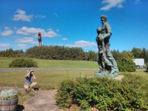
I then continued north, and the trip was fairly uneventful on the way to San Francisco. I met up with Dennis in Berkeley, and we/I headed into the city, and made it to Nick I. and Liana’s (maybe picking up Nick? I think so). I recall going to a place called I think Bloodhound with them, meeting up with David, and Joshua, and Jenny I. We had some drinks and it was a good time. The next day I drove Liana down to Stanford, walked around a bit, and then had lunch with Liana, Jenny R., and Tristan. I think I then went into Berkeley and met up with Nick P. (who was going to be married that weekend) and then Kate at Caffe Strada.

Inside the chapel at Stanford

Perhaps.
After that, I went to Nick M. and Jen’s, from where we went to Ethan and Elisa’s. A bunch of people came over, including Michael, Kate, Robin, maybe cda…I took a bunch of cellphone photos. That night I stayed at Nick and Jen’s, and then the next morning I got up, went over to a bagel place to get some breakfast and watch a bit of one of the World Cup games, and then Jen and I took off.

Kate trying to eat my head
We headed east on I-80, and very shortly made our first stop…at the Jelly Belly Factory. There were a fair number of people there, and we didn’t bother with the tour at all, but did enjoy the shop. I took some photos of the ridiculous flavors they have (they released several “gross” ones after they started selling the Bertie Botts Every Flavor Beans after the popularity of Harry Potter…) We then continued on our way until we met up with I-5 near Sacramento (though generally skirting the city). The area right outside the city where you can clearly see that it is the Delta area is actually pretty neat, some marshlands in an area where I wouldn’t have expected it. We stopped at the Tehama County rest stop off of I-5, and I marvelled at the olive trees they had growing around it. I really think they’ve done quite a nice job at many of these rest stops really making them appropriate for the nearby landscapes and occupations.

At the factory, oh my

I think we’ll pass

Olive tree in front of other olive trees
Anyway, we turned north around Redding, onto CA-44, and headed due east towards Lassen Volcanic National Park. Unfortunately, a lot of the park was still closed for the winter, but the northern half of the park was open to visitors. We drove into the northern part of the park. We got to the park, and admittedly it didn’t look too wintry. We took the road over to the campground (Crags) and set up (I think) then went back towards the park entrance and took a quick walk around Manzanita Lake. It was quite lovely, and we had views of fishers, and the Chaos Crags (fabulous name!). We also drove out to the “Devastated Area”, so named because the explosion of Lassen Peak in 1915 put rock all over this area, destroying a wide swathe of forest. I will freely admit we went to go check it out because of the name, but at this point, it’s pretty much grown back. There was a brief signed nature walk that we took though, which had some interesting information. The part I thought was neatest was the sign saying that “we think rocks are old. this one is under 100 years old”. It was formed at that recent explosion. Crazy.

Peaks in view behind Manzanita Lake

Lassen Peak, with the “Devastated Area” in front of it…
We then went back by the campground and ate and whatnot. I believe that night we also went to a ranger presentation at Manzanita Lake. I *think* it was about the local flowers. The next day we got up and since we couldn’t check out the southern side of the park, we took a ranger’s advice and headed up to the northeast corner of the park to check out the Cinder Cone (which is, of course, a cinder cone…) which is surrounded by the Fantastic Lava Beds. These people really know how to name things!
So, we drove out to that area of the park, and turned down a dirt road to get to the campsite and day use area near Butte Lake. We started walking out to the Cinder Cone, along what is a signed nature trail. I’d paid a quarter or whatever for the little guide pamphlet to the numbered markers, so we got a little bit of the natural history of the region as we went along. The walked is right up against the edge of a lava field, tucked between that and the woods. It is all along a cinder path, so the whole walk is like walking on sand – namely, far more challenging than a flat path should appear to be.

The Cinder Cone, in all its glory
When we got to the cinder cone itself, we were very impressed both at how visible the trail up the side was, and how very steep it looked. Nonetheless, we undertook the journey, and, yup, it was incredibly steep, and the trail was the same terrible cinder footing we’d had before, making every upward step difficult. Nonetheless we made it, and were rewarded at the top (after I collapsed for a bit) with fabulous views in all directions – over the lava fields, looking at nearby lakes, seeing Mt Lassen and the chaos crags, and being able to clearly pick out the trail in the area around us. It was also incredibly windy up top.

Seriously, that’s the trail up

Really wiiiiiiide angle lens to get the breadth of the crater

View out from the top; you can see the two different kinds of lava

You can see the Painted Dunes oxidized flow…so bright
I took a walk around the rim while Jen took the walk to the bottom of the crater and back. While not all that far, I could barely see her at the bottom. While I walked around, I watched some birds having a grand old time for a while playing with some thermal updrafts. I also just stood and shouted into the wind, and couldn’t hear myself for a second – it was fabulous. When we went down, we just run-jumped, in long loping steps, probably sliding at least a foot each time we took another step, but it was a very rapid way of getting down, even if we did have to empty out our shoes at the bottom.

The trail lines cut through the cinder bed

Oxidized, gas-bubbled volcanic rock.

Those little vertical specks are people descending the incredibly steep slope. For reals.
We then walked a bit further out into the plain, until we got to a bit of moving water, then turned and walked back. We then checked out a little bit of trail near Butte Lake, where we had parked. We walked past one small lake whose name I don’t recall, over to another small lake called Bathtub Lake. Then we sat and read a bit by Butte Lake, and when it started getting a bit cooler, we packed up and drove back to the campsite. We went to another ranger talk that night, then went to bed. When I woke up, it had been raining for some while. Jen had apparently woken up while it was raining, decided it couldn’t be too bad if I wasn’t waking up, and then went back to bed. We weren’t super wet, but heh. Anyway, we packed up in the car , with the tent and whatnot spread over everything else to give it a vague chance to dry, and headed further north.

Watching birds play

Jen thinking towards a lake