We left off, having just left Lassen National Park, and we headed off to the next part of our trip – up into the north east corner of California to Lava Beds National Monument, stopping at the way to look at a truly lovely waterfall.

Schonchin Butte, in Lava Beds NM
We stopped for a bit on Highway 89 to check out McArthur-Burney Falls Memorial State Park. I had read that the falls were really great. We asked the park attendant how to get there, and she said the main trail was closed for rehabilitation, and gave us a bit of a walkaround. So we parked, and started out on this alternate path, and of course ended up walking a couple of bonus miles. We had gotten near to the PCT while in Lassen (nearish at Cinder Cone, and it actually crossed our road), but here at the state park we actually intersected with it for a few feet. Anyway, we finally looped all the way around, and then had to go even a bit further up the river, and then finally came back down to where the falls were…and they were beautiful. Absolutely worth taking the time, the extra walking , everything. Wide beautiful falls, with so much early summer water that it was jumping out of crevices everywhere – it was truly beautiful. After admiring for a while, we turned around the way we came, but took the shorter turnoff back to the car, and headed on our way.

Burney Falls
From there, we ducked back to I-5 briefly, past Mt Shasta, north to Weed, where we stopped for some coffee and a snack. From there we headed NE on US97, with some really spectacular views of Shasta to our right. This heads north east through some really beautiful land, with mixed flats and bluffs, with plenty of cinder cones everywhere to remind you of the volcanic origins of the landscape. The expanses were truly spectacular, and the clouds were amazing. The road turns east right at the California/Oregon border, at CA-161, and we drove through flatter marshier area that is several lakes and serves as a wildlife refuge. We saw lots and lots of great birds there – at one point, the road is about the only piece of solid group as it goes past the northern boundary of Lower Klamath Lake. From there, we turned south and headed past Tule Lake, into Lava Beds National Monument.

Passing through Weed

The clouds were amazing
As you enter the monument, the land rises very slightly, and there is a bluff on the right, and then you meet up with the main park road and see the expanse of the park laid out before you. It seems mostly unpreposessing, but that hides a multitude of beauty. Anyway, we drove down to the visitor’s center, picked up a map and a large flashlight, and started checking things out. There are a whole bunch of caves all over the park, mostly from lava tubes. There are many many many of these all over the park, but some of them are set up and labelled, meant for casual visitors, whereas there are books and information about many others if you are more into caving. We stopped around then to to grab a campsite.

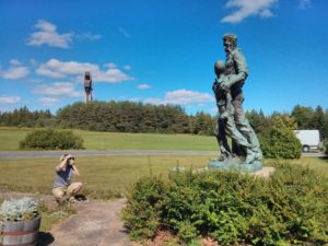
Proof! Evidence photographic. I was there, I swear.
As we weren’t really cavers, we stuck to the ones set up more for visitors – ie, marked, with stairs and partial paths. We went through at least one that was a through path – ie, we went in one end and went out the other. I was walking through, and thinking, man, it’s a bit dim in here, I don’t think my headlmap is working as well as it ought to. It did turn out that my headlamp batteries were fading. Jen, however, also thought her headlamp was a bit dim, but then noticed that she still had her sunglasses on. Hah! Anyway, we then checked out another cave that had a layer of ice on the bottom, though you could only see it through a grill. Apparently they used to have ice skating down there, or at least in places like that. Crazy! We also checked out the most built up cave, which is right behind the visitor’s center, and has a lot of stuff labelled and marked and lit. It’s a little unnerving to see something quite so built up, but on the other hand, I imagine it is really good for teaching kids (and adults!) a lot about the features of the caves, and also can help them limit buildup elsewhere, which is good.

Sunglasses.

View out. It is … really compelling to see the day against the dark.

Heading underground, and looking up. I love this photo.
We then went to the southwest corner of the park, which is higher than much of the rest of the park, and has scrub forest and grasses. We headed out on the Big Nasty Trail, which I of course partially picked because of the name. The trail starts out around the edge of a caldera, and then heads out in the terrain behind. There were big lovely trees, pleasant grasses, lots of evidence of the volcanic landscape – big berms of volcanic rock, with views of cinder cones in the background all very lovely. It was a loop trail, and we had a nice time walking it. We got back to the car, and drove back towards the campground, stopping along the way to take a couple looks and photos of Schonchin Butte in the perfect afternoon light. It’s a notable feature in the center of the park, that has a fire lookout on the top.

Big and … Nasty?

Rocks that are Volcanic
Back at the campsite, we had some dinner, and sat around reading in the waning light. It was really quite beautiful. Later we went over to a ranger talk, about the history of the local Indians, which was somewhat interesting, but was a little weird. She ended up talking about the religious beliefs of the tribes, and was talking about how “people can have all sorts of beliefs, like Christianity, or Judaism, or Scientology <…> “. Scientology? Really? ….ok. Anyway, after laughing for a bit over that, and enjoying the fire, we went back over to the site and went to sleep.

Always nice to read a book

Muted sunset
The next morning, we headed over to Schonchin Butte and took the trail that led to the summit. It was actually a bit steep, but the views were superb – and once you got to the top, you could walk around on the balcony and see everything – Mt Shasta, Mt McLoughlin north in Oregon, all just wonderful. We could look down and see the varous holes in the landscape where the caves were. It was an amazing view of the surrounding landscape, which was all wonerful and new to me. On the walk down, we took a slightly alternate path which took us around the caldera up there, and saw a young buck deer hanging out grazing. I always like seeing the boys with their antlers, since usually you just see a passel of does, so that was nice. Once we got back to the bottom, we got back in the car and headed on our way north.
We headed out the northeast corner of the park, and took brief stop at another unit of the park, Petroglyph Point. This is a large rock butte that apparently used to be sticking up out of the lake when it was a lot larger. People would boat up and carve petroglyphs; now you can just see all the petroglyphs. Very cool.
From there we headed north, and very shortly found ourselves entering into Oregon.

The lava tubes just looked like hungry mouths in the ground

Lava tube and Mt Shasta in the far background